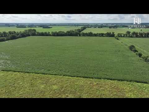
This 80+/- acre farm offers a highly tillable, nearly rectangular tract with predominantly level to gently rolling topography and convenient road frontage along East 600 N. Located just south of U.S. 30 with convenient access to U.S. 35, this property presents an excellent opportunity for farmers and land investors looking to expand their acreage in a strong agricultural area.
PLEASE READ AND REVIEW THE REAL ESTATE TERMS THOROUGHLY PRIOR TO BIDDING ON ANY PROPERTY. IF YOU HAVE NOT READ AND UNDERSTAND THESE TERMS, DO NOT BID. BY BIDDING ON THE PROPERTY, BUYER AGREES TO ALL TERMS AND CONDITIONS SET FORTH AND ENTERS INTO A...
Terms & Conditions
PLEASE READ AND REVIEW THE REAL ESTATE TERMS THOROUGHLY PRIOR TO BIDDING ON ANY PROPERTY. IF YOU HAVE NOT READ AND UNDERSTAND THESE TERMS, DO NOT BID. BY BIDDING ON THE PROPERTY, BUYER AGREES TO ALL TERMS AND CONDITIONS SET FORTH AND ENTERS INTO A CONTRACTUAL AGREEMENT TO PURCHASE THE PROPERTY UNDER THE FOLLOWING TERMS AND CONDITIONS:
ONLINE BIDDING: AUCTION DATE / TIME: Bidding begins: October 13, 2026 @ 4:00 PM CST; Bidding closes: October 13, 2026 @ 6:00 PM CST (**See AUCTION END TIMES). This property will be offered in one (1) tract as a whole farm. Each bid shall constitute an offer to purchase and the final bid, if accepted by the Sellers, shall constitute a binding contract between the Buyer(s) and the Sellers. The auctioneer will settle any disputes as to bids and his decision will be final. To place a confidential phone, mail or wire bid, please contact Nolan Sampson at (219)575-1486 or AJ Jordan at (317)697-3086 at least two days prior to the sale.
UPON CONCLUSION OF THE AUCTION: The Sellers reserve the right to accept or reject all bids. All successful bidders must enter into a purchase agreement the day of the auction, immediately following the conclusion of the bidding. The successful bidders will receive a Real Estate Contract and are required to fully and correctly complete and properly sign without any modifications. Bidders are to return the completed, signed contract to Halderman Real Estate Services, Inc. by email, fax or delivered in person by 4:00 PM of the day following the auction. Along with the completed, signed contract, the winning bidders will be required to send the specified non-refundable earnest money deposit as stated in the real estate terms. This non-refundable earnest money deposit will be held in escrow until closing and that amount will then be credited to the Buyer(s) as part of the purchase price of the property. Wire transfer instructions will be provided to the Buyer(s) along with the contract after the auction. Purchaser shall be responsible for all wire transfer fees.
Successful bidders not executing and returning the completed contract and earnest money deposit by 4:00 PM the day after the auction will be considered in default. Such default by the Successful Bidder will result in that Bidder’s liability to both the Seller and Halderman Real Estate Services, Inc. Seller shall have the right to (a) declare this contractual agreement cancelled and recover full damage for its breach, (b) to elect to affirm this contractual agreement and enforce its specific performance or (c) Seller can resell the property either publicly or privately with Halderman Real Estate Services, Inc. and in such an event, the Buyer shall be liable for payment of any deficiency realized from the second sale plus all costs, including, but not limited to the holding costs of the property, the expenses of both sales, legal and incidental damages of both the Seller and Halderman Real Estate Services, Inc. In addition, Halderman Real Estate Services, Inc. also reserves the right to recover any damages separately from the breach of the Buyer.
Both the Successful Bidder and Seller shall indemnify Halderman Real Estate Services, Inc. for and hold harmless Halderman Real Estate Services, Inc. from any costs, losses, liabilities, or expenses, including attorney fees resulting from Halderman Real Estate Services, Inc. being named as a party to any legal action resulting from either Bidders or Sellers failure to fulfill any obligations and undertakings as set forth in this contractual agreement.
REAL ESTATE TERMS:
• TERMS OF SALE: 10% earnest deposit down with the executed contract, balance due at closing. Your purchase is not subject to financing.
• CONTINGENCIES: This Real Estate contract is not contingent on or subject to Buyer’s financing, appraisal, survey or inspections of any kind or any other contingencies as agreed to by bidders at registration prior to bidding.
• ACREAGE: The acreages listed in this brochure are estimates taken from the county assessor’s records, FSA records and/or aerial photos.
• DATE OF CLOSING: Closing will occur on or before November 27, 2026. The Sellers have the choice to extend this date if necessary.
• POSSESSION: Possession of the land will be at closing, subject to the tenant’s rights to the 2026 harvest.
• PERSONAL PROPERTY: No personal property is included in the sale of the real estate.
• REAL ESTATE TAXES: The Sellers will pay real estate taxes for 2026 due 2027. Buyer will be given a credit at closing for the 2026 real estate taxes due 2027 and will pay all taxes beginning with the spring 2027 installment and all taxes thereafter.
• SURVEY: The Sellers reserve the right to determine the need for and type of survey provided. If an existing legal description is adequate for title insurance for the tract, no new survey will be completed. If the existing legal description is not sufficient to obtain title insurance, a survey will be completed, the cost of which will be shared 50/50 by the Sellers and the Buyer(s). The Sellers will choose the type of survey to be completed and warrant that it will be sufficient to provide an owner’s title insurance policy for the tract. If a survey is completed, the purchase price for the surveyed tract will be adjusted, up or down, to the exact surveyed acres. The price per acre will be the auction price bid for the tract, divided by the tract acreage estimated in the auction brochure.
• FARM INCOME: Seller will retain 2026 farm income.
• DEED: The Sellers will provide a General Warranty Deed at closing.
• EVIDENCE OF TITLE: The Sellers will provide an Owner’s Title Insurance Policy to the Buyer(s). Each Buyer is responsible for a Lender’s Policy, if needed. If the title is not marketable, then the purchase agreement(s) are null and void prior to the closing, and the Broker will return the Buyer’s earnest money.
• ZONING AND EASEMENTS: Property is being sold subject to all easements of record. Property is subject to all state and local zoning ordinances.
• AERIAL PHOTOS, Images and Drawings: are for illustration purposes only and not surveyed boundary lines unless specified.
• MINERAL RIGHTS: All mineral rights owned by the Sellers will be conveyed to the Buyer(s).
• PROPERTY INSPECTION: Each potential Bidder is responsible for conducting, at their own risk, their own independent inspections, investigation, inquiries, and due diligence concerning the property. Further, Sellers disclaim all responsibility for bidder’s safety during any physical inspections of the property. No party shall be deemed to be invited to the property by HRES or the Sellers.
• AGENCY: Halderman Real Estate Services, Inc. is the Agent and Representative of the Seller.
• BID RIGGING: Bid Rigging is a Federal Felony. Auctioneer will report illegal activity by any person to the FBI for investigation and prosecution. Title 15, Section 1 of the U.S. Code makes any agreement amongst potential bidders not to bid against one another, or to otherwise dampen bidding illegal. The law provides for fines of up to $100,000,000 for a corporate offender and $1,000,000 for an individual, plus imprisonment for up to 10 years.
• DISCLAIMER: All information contained in this brochure and all related materials are subject to the Terms and Conditions outlined in the purchase agreement. This information is subject to verification by all parties relying upon it. No liability for its accuracy, errors or omissions is assumed by the Sellers or HRES. All sketches and dimensions in this brochure are approximate. ANNOUNCEMENTS MADE BY HRES AND/OR THEIR AUCTIONEER AT THE AUCTION DURING THE TIME OF THE SALE TAKE PRECEDENCE OVER ANY PREVIOUSLY PRINTED MATERIALS OR ANY OTHER ORAL STATEMENTS MADE. The property is being sold on an “AS IS, WHERE IS” basis, and no warranty or representation, either express or implied, concerning the property is made by the Sellers or HRES. No environmental audit has been made, nor will one be made. Except for any express warranties set forth in the sale documents, Buyer(s) accepts the property “AS IS,” and Buyer(s) assumes all risks thereof and acknowledges that in consideration of the other provisions contained in the sale documents, Sellers and HRES make no warranty or representation, express or implied or arising by operation of law, including any warranty for merchantability or fitness for a particular purpose of the property, or any part thereof, and in no event shall the Sellers or HRES be liable for any consequential damages.
• NEW DATA, CORRECTIONS, and CHANGES: Please check for updated information prior to scheduled auction time to inspect any changes, corrections, or additions to the property information.
BIDDING AND REGISTRATION INFORMATION
BIDDER VERIFICATION: Bidding rights are provisional, and if identity verification is questionable, Halderman Real Estate Services, Inc. has the right to reject the registration, and bidding activity will be terminated. The Seller and Halderman Real Estate Services, Inc. reserve the right to preclude any person from bidding if there is any question as to the person's credentials, mental fitness, etc. Bidders agree to keep their username and password confidential as they are responsible for ALL activity involving their account. If the registered bidder's user name is offensive to Halderman Real Estate Services, Inc. or in their sole opinion detrimental to Bidding Activity, then Halderman Real Estate Services, Inc. reserves the right to delete the bidder from bidding or unilaterally change the username with notification to the Bidder. When using the website, you must obey all local, state, and federal laws. Violations will result in termination of web site use privileges.
**AUCTION END TIMES: Halderman Real Estate Services, Inc. online only auctions are timed events and all bidding will close at specified time. However, our auctions also have what is called an 'Auto Extend' feature. Any bid placed within the final 5 minutes of an auction results in the auction automatically extending 5 additional minutes. The bidding will extend in 5-minute increments from the time the last bid is placed until there are no more bids, and the lots sit idle for 5 minutes. Therefore, the auction will not close until all bidding parties are satisfied and no one can be outbid at the last second without having another opportunity to bid again.
TECHNICAL ISSUES: In the event there are technical difficulties related to the server, software, internet or any other online auction-related technologies, Halderman Real Estate Services, Inc. reserves the right to extend bidding, continue the bidding, or close the bidding. Neither the company providing the software, nor Halderman Real Estate Services, Inc. shall be held responsible for a missed bid or the failure of the software to function properly for any reason.
CONDUCT OF THE AUCTION: The minimum bid increase will be $5,000. Halderman Real Estate Services, Inc. reserves the right to reject all bids for any reason and reserves the right to cancel this auction, or remove any item or lot from this auction prior to the close of bidding. All decisions of Halderman Real Estate Services, Inc. are final.
YOUR BID ON THIS AUCTION INDICATES BOTH AN UNDERSTANDING AND AN ACCEPTANCE OF THE TERMS OF THIS CONTRACTUAL AGREEMENT BETWEEN YOURSELF AND BOTH THE SELLER AND HALDERMAN REAL ESTATE SERVICES, INC. AND THAT YOU, AS THE BIDDER, ARE PREPARED TO PURCHASE THE PROPERTY UNDER THE TERMS AND CONDITIONS OF THIS AUCTION.
Select FULL SCREEN to expand the map and navigate the property including boundary lines, location and nearby cities. Additional assistance in navigating the interactive map can be accessed by selecting VIEW TUTORIAL. The LAYERS & BASEMAPS button provides the option to preview the property in various views such as street or satellite view as well as access soil types, township and county lines.
RegionIN
General Location4.5 miles southeast of Hanna, IN East of Range Rd South of 600 N, (41.3895963, -86.6924306).
Legal DescriptionParcel ID: 75-02-19-100-002.000-015
Legal Description: E 1/2 Nw 19 34 2 80 A